DISTRICT 1
 ALL THAT area of the parish of St. James comprising Paradise Heights, West Terrace, Oxnards, Oxnards Heights, Husbands, Husbands Heights, Wanstead Terrace, Wanstead Gardens and Wanstead Heights, which area is bounded to the SOUTH by University Drive, to the NORTH by Oxnards Road and lands of National Housing Corporation, to the EAST by Husbands Road (as far as the junction with Oxnards Road) and to the WEST by the escarpment forming the boundary between West Terrace and lands of sundry owners below the said escarpment.
This District includes areas such as Paradise Heights, West Terrace, Oxnards, Husbands, Cave Hill and Wanstead.
DISTRICT 2
 ALL THAT area of land situate in the parishes of St. Michael, St. James and St. Thomas, comprising Thorpes, Halls Village, Prior Park, Prior View Heights, Prior Park Gardens, Prior Hill, Prior Park Heights, Clermont, Meadowvale Heights, Warrens Park (North), Warrens Terrace, Warrens Terrace (West) and Warrens and starting from the junction of the Husbands and Clermont Roads and then northwards along the Husbands Road to the junction at Thorpes with the road leading to St. John the Baptist Church; then along this road in a generally easterly direction to its junction with the Prior Park Road and easterly along this to its junction with Highway 2A; then in a southerly direction along Highway 2A to its junction with Clermont Road; then in a westerly direction along Clermont Road back to the starting point.
This District includes areas such as Clermont, Prior Park, Crystal Heights, Halls Village, Redmans Village and Thorpes.
DISTRICT 3
 ALL THAT area of land situate in the parish of St. Michael, comprising Clerview Heights. Clermont, Warrens Park South, Lodge Terrace, Eden Lodge, the western side of Green Hill, the eastern side of White Hall, Rock Dundo Park, Rock Dundo Heights, Well Gap, Lodge Hill, West Road, Airlie Tenantry and Hinds Hill commencing from the junction of Husbands Road and Clermont Road and continuing along Clermont Road to its junction at Warrens with Highway 2A, then along Highway 2A to the roundabout where it joins the Gordon Cummins Highway, then along the Gordon Cummins Highway to the Warrens roundabout, then along Green Hill Road to its junction with White Hall Road then along White Hall Road to its junction at Hinds Hill with the Gordon Cummins Highway, then along Husbands Road to its junction with Clermont Road.
This District includes areas such as Clermont, Warrens, Lodge Hill, Eden Lodge, Whitehall, some parts of Green Hill and Rock Dundo Park.
DISTRICT 4
 This area is bounded by the Tom Adams section of the ABC Highway, Kingland Road, Wotton Terrce and Plumgrove.
This District specifically includes Kingsland Park, Kingsland Crest, Kingsland Heights, Kingsland Terrace (Stages 1-3), Kingsland Terrace North, Kingsland Gardens North and Kingsland Gardens South.
DISTRICT 5

ALL THAT area of land situate in the parish of Saint Philip bounded by Highway N, Gemswick Road and Roses Tenantry.
This area specifically included Gemswick Terrace, Gemswick Gardens, Belleview Gardens, Durette Gardens and Gemswick.
DISTRICT 6
 This area is bounded by the section of the ABC Highway between the Warrens and Simpson Motors roundabouts, Highway 2A, Melrose Road, Arthurs Seat Road and Highway 2 (Jackson Road).
This District includes areas such as Warrens, Millenium Heights, and Welches.
DISTRICT 7
 ALL THAT area of land situate in the parish of Christ Church starting at the Junction of Upton (part of the ABC Highway) and Highway “R” at Wildey. The boundary then runs generally eastwards along highway “R” to St. Davids and the junction with highway “V”; then in a generally south-easterly direction along highway “V” to its junction at Bannatyne with highway 6; then south-westerly, westerly and north-westerly along highway 6 passing through Kingsland, Adams Castle, Vauxhall, Sheraton, Sargeant’s Village, Elizabeth Park, Regency Park to the junction by BET Playing field (part of the ABC highway); then northward along the ABC Highway (between Shell Wildey and BET) back to the starting point.
This District includes areas such as Sargeants Village, Kingsland, Adams Castle, Kent, Vauxhall, Sheraton Park, Elizabeth Park and Regency Park.
DISTRICT 8
 All that area of land situate in the parish of St. Philip commencing at the road which leads from the Crane Beach, the boundary then runs in a north, northwesterly and then in a northeasterly direction along Highway N to the junction with Union Road, then in a northwesterly direction, along Union Road to the junction with Highway 5, then in a northeasterly direction, easterly, then in a northeasterly direction along Highway 5 to the junction with the road at Applehall which leads to Bottom Bay, then in a south easterly direction along the road which ends at Bottom Bay.
This District includes areas such as Union, Apple Hall, Belair, Long Bay, Shrewsbury Gardens, Castle Heights, Work Hall, Seaview, Eastbourne, Ruby Park, Harmony Hall and Crane.
DISTRICT 9
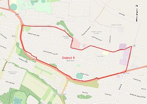 All that area of land situate in the parish of Christ Church, commencing at the Edwy Talma Roundabout in a westerly direction along the ABC highway through the Errol W. Barrow Roundabout to the Garfield Sobers Roundabout then in an easterly direction along Highway 6, to the junction of Highway 6 and Warners, then continuing eastward along Highway 6 to the junction of Highway 6 and Kendal Hill, then in a southerly direction to the Edwy Talma Roundabout, comprising Warners, Warners Gardens, Warners Park, Warners Terrace, Sergeants Village, Bartletts Tenantry, Brownes Gap, Smith Corner, Apple Grove, Graeme Heights Development, Graeme Hall, Tino Terrace, Vauxhall, Vauxhall Gardens, Sunset Gardens, Briar Hall, Barrack Hill and Wotton Plantation.
DISTRICT 10
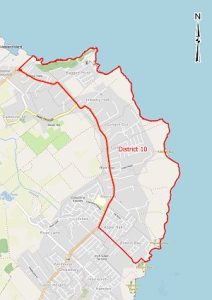 All that area of land situate in the parish of St. Philip, commencing at Bottom Bay proceeding along the southeastern side of the Bottom Bay/Applehall Road in a northwesterly direction to its junction with Highway 5B then continuing in a northerly direction along Highway 5B, until its junction with Hill View Road then continuing in an easterly direction along Hill View Road to include parcels located south of the road, until it meets the sea, then continuing along the coast in a southerly direction to the point of commencement comprising Applehall, Merricks, Coles, Coles Pasture, Coles Terrace, Coles Close, Coles Crescent, Content Cot, Industry Hall, Hill Drive, Hill View, Peat Bay, Ragged Point, Sealy Hall, East Point and Marley Vale.